App Builder

Build apps without limits

Build complete GIS web applications from production-ready templates. Add ready-made widgets and adapt them to your needs, deploy a database in seconds, and let REGIS Builder build with you.

European Union, Copernicus Sentinel-2 imagery 2020 - USA and Canada

Build your application, your way.

Start from a template, an existing map or a blank project. Then use AI to build and customize the experience around your workflow.

Start

Start your way: from a template, an existing web map, or a blank canvas.

Build & customize with AI

Describe your needs. The AI creates, adapts and explains the custom code, widgets and logic behind your app.

Deploy on your terms

Hosted by us, or deployed on your terms. Your code stays yours.

REGIS Builder Build in minutes

Describe. Build. Customize.

Chat with REGIS Builder and let it build exactly what you need. Watch your application evolve and interact with it in the live preview.

  • Two modes: Ask (read-only) and Build (auto mode)Ask about your project, then let Build make the changes.
  • Watch changes in a live mapSee updates as they happen.
  • Layers, styles and widgets stay configurableEach through its dedicated menu, and you can edit the code yourself.

Use AI to customize every part of the app.

  • Ready to useInstall from the gallery in a few clicks
  • AI-madeImprove one or generate a new one
  • Your codeEvery widget is code you can edit

Widgets

Widgets, without limits

Choose. Configure. Extend. Create.

Install ready-to-use widgets from the gallery and configure them yourself or with the AI. If one does not fit, improve it or create something entirely new, instantly.

Widgets, yours to shape
  • Start with speed.
  • Shape with control.
  • Extend with AI.
  • Create without compromise.

Real applications, built with ALIGN.

From internal tools to public portals, build the GIS application your workflow actually needs.

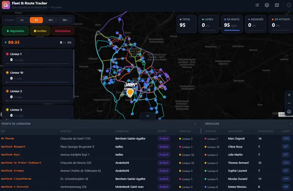
Operations dashboard

Live assets, filters and KPIs

A fleet and route tracker application: delivery rounds on a map of Brussels with live KPIs

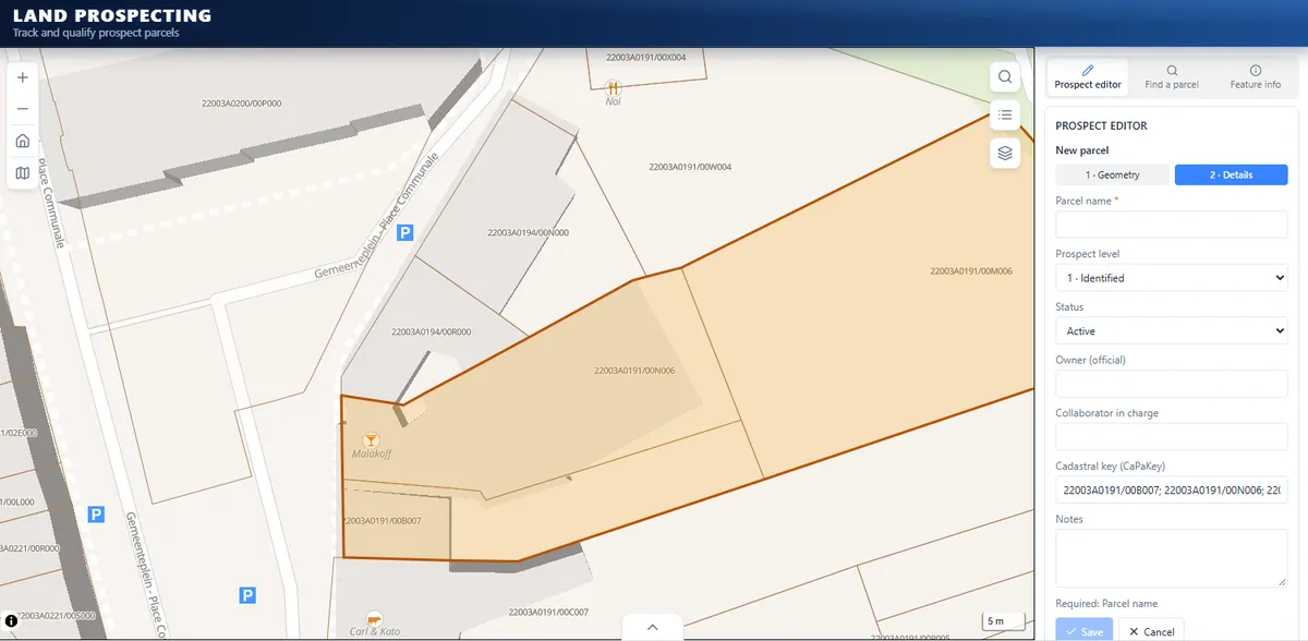
Land prospecting tool

Draw, qualify and track parcels

A land prospecting application: a prospect parcel drawn over the cadastre, with its details form (prospect level, status, owner, cadastral key)

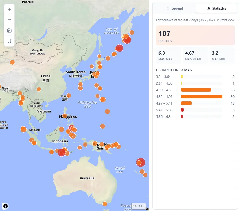
Decision-support tool

Analysis, scenarios and reporting

An earthquake monitoring application: the last week's earthquakes (USGS) on a world map, with a statistics panel of counts and magnitudes
A PostgreSQL + PostGIS database provisioned for an ALIGN app, with its spatial schema of routes, delivery points and vehicles open in the visualizer
  • AI-readyLet REGIS Builder design your schema and queries
  • Datastore importBring your layers into your app
  • Connect your ownUse an existing Supabase project

Database

Deploy spatial data in seconds

Connect Supabase and provision a PostgreSQL + PostGIS database without managing infrastructure.

Let REGIS Builder build around your data: schema, queries, backend logic and app integrations.

Bring existing layers from the Datastore straight into your application.

PostgreSQL + PostGIS
  • Provision or connect instantly
  • Visualize and manage your spatial schema
  • Query, edit and secure your data
  • Built for geospatial workflows

Deployment

Deploy on your terms

Let ALIGN host your application, or push it to GitHub and run it on the infrastructure of your choice.
Either way, the code stays yours.

Coming soon Hosted by ALIGN One click to go live: we run it, you get a preview URL and can point your own domain.
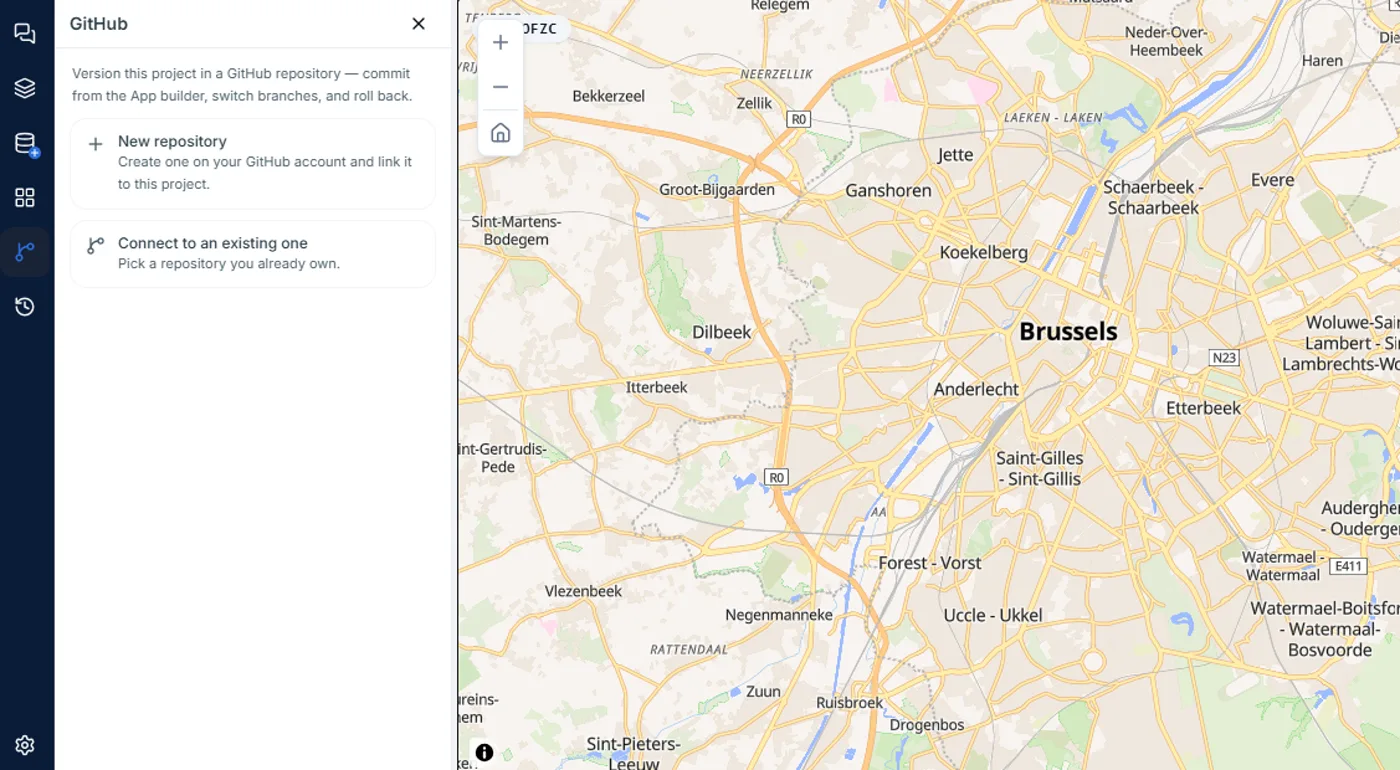
Team plan Your own infrastructure Push to GitHub and deploy anywhere, with no ALIGN runtime dependency.
The GitHub panel of the App Builder, offering to create a new repository or connect an existing one
Start building for free